Texas A&M University Student Housing
Comprehensive facade and thermal roof assessment of a 10.1-acre, 3-building student housing complex at Texas A&M University. 41 flights and 13,000+ images captured in the active landing path of Easterwood Airport after six weeks of multi-agency airspace coordination.
0.06 in/px
Facade Resolution
3
Buildings Scanned
10.1 acres
Site Area
0.3 in/px
3D Model Resolution
120 ft AGL
Altitude Ceiling
4
Agencies Coordinated
Project Overview
The Full Story
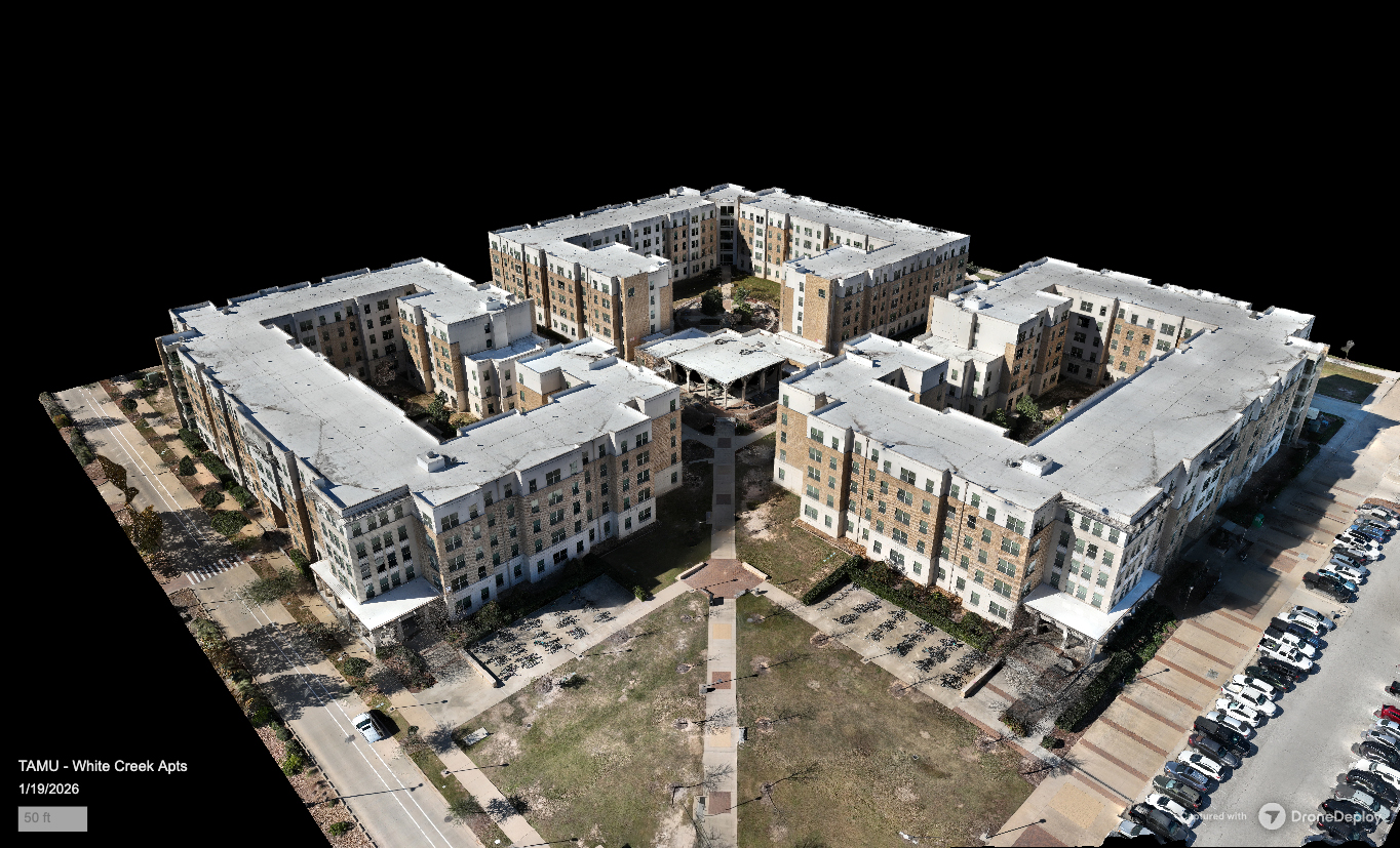
When Texas A&M University initiated a transition in building management for one of its largest student housing complexes, they needed a comprehensive, objective record of every facade and rooftop. The assessment would serve as the definitive baseline: documenting the exact condition of every exterior surface at the moment responsibility changed hands.
Zero/Six Consulting engaged LittleBird to deliver the data capture for all three multi-story buildings across the 10.1-acre site. The scope included high-resolution facade scans of every building, a full-site 3D photogrammetric model, and radiometric thermal roof imagery for each structure.
The challenge was location. The housing complex sits directly beneath the approach path for Easterwood Airport, College Station's primary airport serving commercial and military traffic. Every flight required coordination not just with the FAA, but with live air traffic control operations. LittleBird spent six weeks building the authorization framework before the first flight, coordinating across four separate agencies: the Texas A&M University Office of Risk Management, Texas A&M University Police Department, FAA LAANC, and Easterwood Airport air traffic control.
Over three consecutive days, LittleBird executed systematic facade scans of all three buildings using the DJI Mavic 3 Enterprise at approximately 20-foot standoff distances, achieving 0.06 in/px resolution capable of resolving individual sealant joints, fastener conditions, and hairline surface anomalies. All flights were conducted under a 120-foot altitude ceiling while monitoring flight radar and ATC radio, with aircraft operating in close proximity throughout each day.
After the final day of facade capture, LittleBird returned after dark to conduct radiometric thermal scans of every rooftop using the DJI Mavic 3T. Nighttime capture was a deliberate technical decision: after a full day of solar loading, the buildings' thermal mass creates maximum contrast between properly performing roof assemblies and areas with moisture intrusion, insulation deficiencies, or membrane failures.
The result: 41 flights, over 13,000 images, and 8 hours 34 minutes of total flight time across four days, producing a complete digital record of every exterior surface. All data was processed and delivered through DroneDeploy as an uninterpreted, raw-processed dataset for Zero/Six Consulting's independent assessment.
41 flights, 13,000+ images, and 8 hours 34 minutes of flight time across 4 days. 0.06 in/px facade resolution in an active airport landing path with continuous ATC monitoring. Six weeks of multi-agency coordination. Zero safety incidents.
Additional Metrics
Equipment
Project Media
See the Work
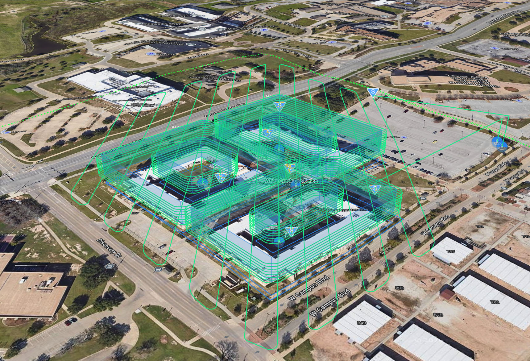
FlightHub2 mission planning view showing systematic facade scan flight paths across all three buildings in controlled airspace near Easterwood Airport.
What We Delivered
Project Deliverables
Every engagement produces tangible, documented outputs your team can use to take action.
Full-Site 3D Model
Complete photogrammetric 3D reconstruction of the entire housing complex and surrounding context at 0.3 in/px, enabling virtual walkthroughs, measurement, and spatial analysis from any angle.
Per-Building Facade Orthomosaics
Each building rendered as a high-resolution, dimensionally accurate facade orthomosaic at 0.06 in/px. Organized by building for systematic review by the consulting team.
Radiometric IR Roof Scans
Nighttime thermal orthomosaics for each building's roof assembly, captured post-solar loading for maximum thermal contrast between performing and compromised roof areas.
Elevation Model
Precision elevation data derived from the photogrammetric point cloud, providing accurate height measurements and topographic context across the 10.1-acre site.
DroneDeploy Project Hub
All models, orthomosaics, and thermal data accessible through DroneDeploy with interactive 3D viewing, measurement tools, and export capabilities for the consulting team.
Impact
Who This Served
The deliverables from this project served multiple audiences, each with distinct needs and access requirements.
For Property Managers
Asset Owners & Management
A comprehensive visual and thermal record created at the exact moment of management transition. Objective documentation that protects both incoming and outgoing parties from disputed conditions.
For the Consultant
Zero/Six Consulting
High-resolution facade orthomosaics and radiometric thermal roof data delivered through DroneDeploy, ready for independent analysis. No annotations or interpretations imposed on the data.
For the Institution
Texas A&M University
Six weeks of multi-agency coordination, FAA authorization, direct ATC communication, and zero incidents across 41 flights. The level of operational rigor that institutional environments demand.
More Projects
Explore Other Case Studies
Ball High School North Campus
19 months of precision aerial documentation capturing a brand-new school from bare dirt to completion. 108 flights, 28,457 images, and transparent deliverables serving the consultant, stakeholders, and the Galveston community.
UTA University Center Roof Assessment
Combined visible-light and radiometric thermal roof assessment of the E.H. Hereford University Center at The University of Texas at Arlington.
Your Project Could Be Next
Tell us about your building or site and we'll show you what's possible.