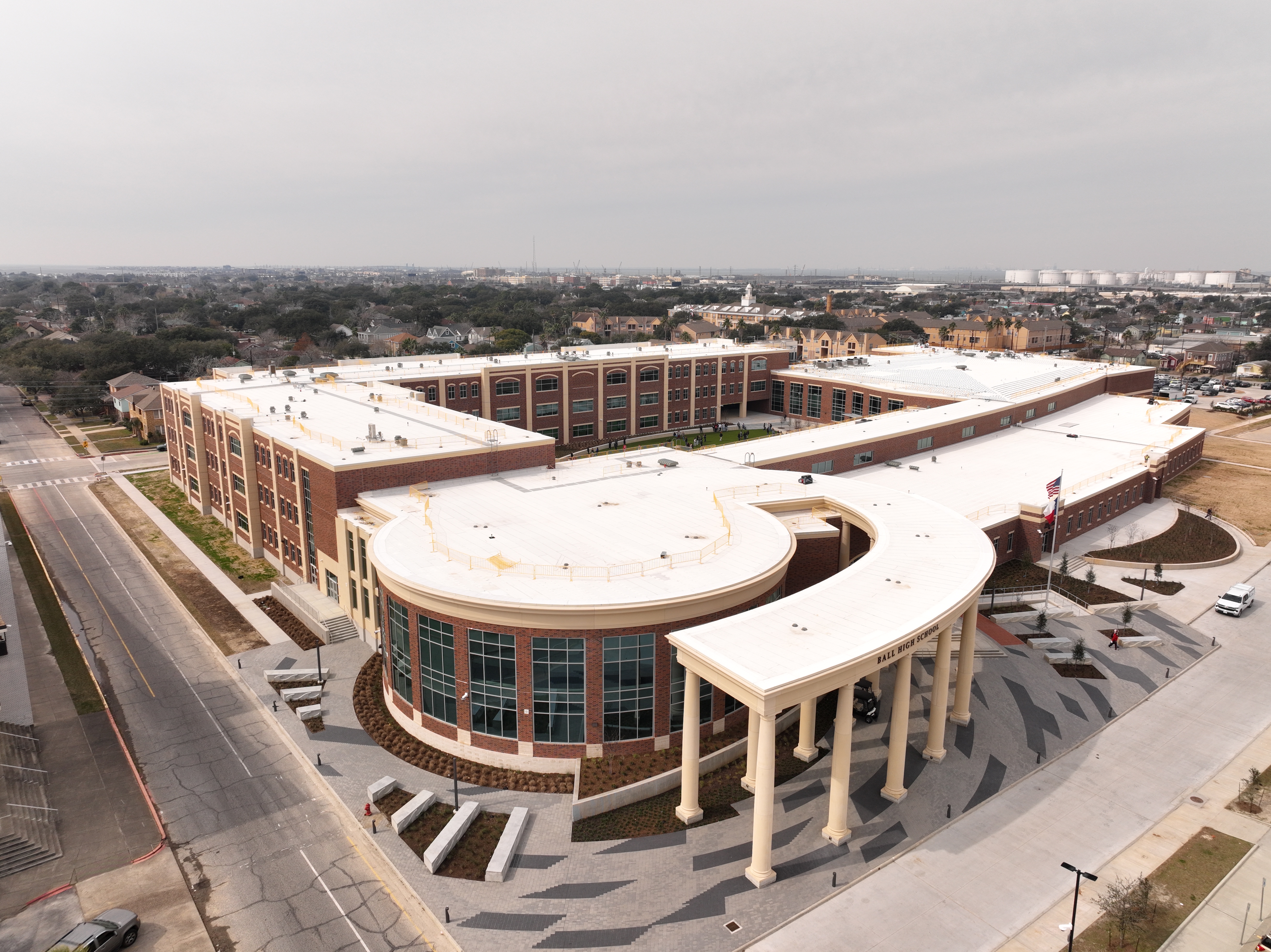
Ball High School North Campus
19 months of precision aerial documentation capturing a brand-new school from bare dirt to completion. 108 flights, 28,457 images, and transparent deliverables serving the consultant, stakeholders, and the Galveston community.
108
Total Flights
28,457
Images Captured
28
Capture Sessions
19 months
Project Duration
18.8 acres
Site Area
20h 25m
Total Flight Time
Project Overview
The Full Story
LittleBird was sub-contracted by Zero/Six Consulting to provide ongoing aerial construction documentation for the Ball High School North Campus project in Galveston, Texas. The scope called for scheduled monthly capture sessions across the full duration of construction, from initial site preparation through final completion.
Over 19 months, LittleBird executed 28 onsite capture sessions encompassing 108 individual flights. Each session produced a complete data package: orthomosaic site maps, 3D photogrammetric models, dense point clouds, digital elevation and surface models, and volumetric stockpile calculations. All mapping flights were RTK-enabled using the DJI Mavic 3 Enterprise, achieving 0.34 in/px ground sample distance and 0.2 ft RMSE positional accuracy with RTK and PPK correction.
In addition to the mapping missions, creative aerial flights were conducted using the DJI Mavic 3 Air and DJI Neo to produce cinematic progress updates for Galveston ISD. These visual updates gave the school board and the broader Galveston community a transparent window into their new school taking shape, providing visual accountability at every major construction milestone.
The deliverables served triple duty: comprehensive visual documentation for Zero/Six Consulting's oversight requirements, measurable progress verification for lenders and project stakeholders, and community-facing visual updates that kept the school board and public informed throughout the 19-month build. All data was delivered through DroneDeploy with tiered access for different stakeholder groups.
28,457 images across 108 flights over 19 months, delivering sub-inch resolution and sub-foot accuracy at every milestone. Zero safety incidents. Complete transparent oversight from bare dirt to a finished school.
Additional Metrics
Equipment
Project Media
See the Work
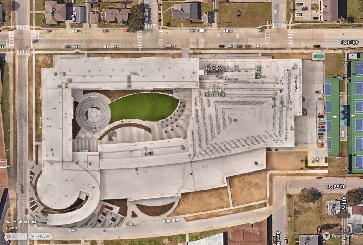
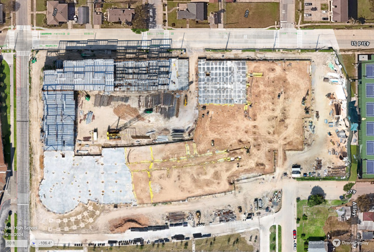
Side-by-side orthomosaic comparison showing the full transformation from site preparation to completed campus.
What We Delivered
Project Deliverables
Every engagement produces tangible, documented outputs your team can use to take action.
Monthly Orthomosaic Site Maps
High-resolution orthomosaics at every milestone with precise measurements, exportable as GeoTIFF for integration with project management and GIS workflows.
3D Photogrammetric Models
Full-site 3D reconstructions at each capture session, allowing remote stakeholders to navigate the site and verify conditions from any angle.
Dense Point Clouds
LAS-format point clouds for spatial analysis, measurement, and CAD integration at every documented milestone.
DEM/DSM Elevation Models
Digital elevation and surface models tracking grading, drainage, and terrain changes throughout the construction timeline.
Stockpile Volume Calculations
Volumetric measurements of material stockpiles at each session, tracking earthwork quantities and material inventory over time.
Cinematic Progress Updates
Aerial video content produced for Galveston ISD, providing the school board and community with visual progress reports at major construction milestones.
Progress Comparison Overlays
Side-by-side orthomosaic comparisons and timelapse sequences documenting the full construction arc from site prep to completion.
Impact
Who This Served
The deliverables from this project served multiple audiences, each with distinct needs and access requirements.
For the Consultant
Zero/Six Consulting
Comprehensive visual record at every milestone meeting Zero/Six Consulting's documentation and oversight requirements. All data delivered through DroneDeploy with analyst-level access for the consulting team.
For Stakeholders
Lenders & Project Owners
Measurable, timestamped progress verification at every construction milestone. Orthomosaics, elevation models, and stockpile calculations provided defensible documentation for pay applications and schedule tracking.
For the Community
Galveston ISD & School Board
Cinematic aerial updates gave the school board and Galveston community a transparent window into their new school taking shape. Visual accountability at every major milestone built public trust throughout the 19-month construction timeline.
More Projects
Explore Other Case Studies
Texas A&M University Student Housing
Comprehensive facade and thermal roof assessment of a 10.1-acre, 3-building student housing complex at Texas A&M University. 41 flights and 13,000+ images captured in the active landing path of Easterwood Airport after six weeks of multi-agency airspace coordination.
UTA University Center Roof Assessment
Combined visible-light and radiometric thermal roof assessment of the E.H. Hereford University Center at The University of Texas at Arlington.
Your Project Could Be Next
Tell us about your building or site and we'll show you what's possible.